 Integrating photos has never been this easy.
Wind Image for ArcMap
Wind Image Stand Alone
Wind Image Transfer
Flawless image integration for ArcGIS users. Imprint date
time, GPS position and attributes right onto your photos.
Process photos into hyperlinked and raster embedded datasets
and process Ricoh track-logs. Wind image supports
all coordinate systems supported within ArcMap and all ESRI
Geo-database types (Personal,File and ArcSde). Other Features
include: Native Support in both ArcMap and ArcReader for
viewing raster embedded datasets, photo thumbnail viewer,
a robust set of photo editing tools and integrated layout tools
for printing maps with your images.
Click here for more information.
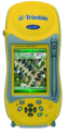
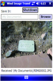
Wind Image Transfer allows for easy connectivity between
the Ricoh 500SE-WIFI camera and Trimble Devices*. Transfer
allows users to select the location where images are delivered
and enables images to be sent from the camera automatically
as soon as the picture is taken. Built in Viewer allows users to
view pictures as they are received on the mobile device.
Wind Image Transfer delivers images for use with any
application such as ArcPad and TerraSync.
Bonus Feature:
Only occupies WIFI connection while in use, once Transfer is
closed WIFI service is available for other connections.
Click here for more information.
Integrating photos has never been this easy.
Wind Image for ArcMap
Wind Image Stand Alone
Wind Image Transfer
Flawless image integration for ArcGIS users. Imprint date
time, GPS position and attributes right onto your photos.
Process photos into hyperlinked and raster embedded datasets
and process Ricoh track-logs. Wind image supports
all coordinate systems supported within ArcMap and all ESRI
Geo-database types (Personal,File and ArcSde). Other Features
include: Native Support in both ArcMap and ArcReader for
viewing raster embedded datasets, photo thumbnail viewer,
a robust set of photo editing tools and integrated layout tools
for printing maps with your images.
Click here for more information.
Wind Image Transfer allows for easy connectivity between
the Ricoh 500SE-WIFI camera and Trimble Devices*. Transfer
allows users to select the location where images are delivered
and enables images to be sent from the camera automatically
as soon as the picture is taken. Built in Viewer allows users to
view pictures as they are received on the mobile device.
Wind Image Transfer delivers images for use with any
application such as ArcPad and TerraSync.
Bonus Feature:
Only occupies WIFI connection while in use, once Transfer is
closed WIFI service is available for other connections.
Click here for more information.

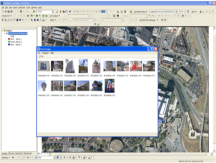
 Wind Image Stand Alone is the ultimate application for
processing images outside of any other program. Users
can process images using the Wind Image Stand Alone
application accessing a robust set of photo editing tools
(i.e. crop, rotate, touch up, red eye reduction, focal blur, etc.)
as well as explore the advanced tools for: reporting, documenting,
creating kmz, and kml files for use in Google earth, as well as
creating Google web maps which ultimately allows users to
view images and information in a mapping environment over
the world wide web. The advanced image imprinting tools within
our Stand Alone application allows users the ability to imprint
information such as GPS data, Ricoh memo fields, logos, and
personalized text. This application enables users of all skill levels
to become more active and explorative when integrating
their geo-tagged images to the next level.
Click here for more information.
Wind Image Stand Alone is the ultimate application for
processing images outside of any other program. Users
can process images using the Wind Image Stand Alone
application accessing a robust set of photo editing tools
(i.e. crop, rotate, touch up, red eye reduction, focal blur, etc.)
as well as explore the advanced tools for: reporting, documenting,
creating kmz, and kml files for use in Google earth, as well as
creating Google web maps which ultimately allows users to
view images and information in a mapping environment over
the world wide web. The advanced image imprinting tools within
our Stand Alone application allows users the ability to imprint
information such as GPS data, Ricoh memo fields, logos, and
personalized text. This application enables users of all skill levels
to become more active and explorative when integrating
their geo-tagged images to the next level.
Click here for more information.