 Wind Image Standalone
 Wind Image Standalone
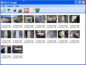
Wind Image Stand Alone is the ultimate application for processing
images outside of any other program. Users can process images
using the Wind Image Stand Alone application accessing a robust set
of photo editing tools (i.e. crop, rotate, touch up, red eye reduction,
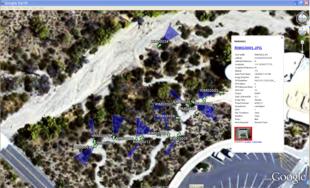
focal blur, etc.) as well as explore the advanced tools for: reporting,
documenting, creating kmz, and kml files for use in Google earth, as
well as creating Google web maps which ultimately allows users to
view images and information in a mapping environment over the world
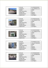
wide web. The advanced image imprinting tools within our Stand
Alone application allows users the ability to imprint information such
as GPS data, Ricoh memo fields, logos, and personalized text. This
application enables users of all skill levels to become more active and
explorative when integrating their geo-tagged images to the next level.
Click here to download the Wind Image brochure
Click here to download the Wind Image Software comparison brochure
Click here to download a trial of Wind Image Standalone
Click here to purchase a copy of Wind Image Standalone online
Click here to watch Wind Image Training & Support videos online
Wind Image Standalone
Wind Image Stand Alone is the ultimate application for processing
images outside of any other program. Users can process images
using the Wind Image Stand Alone application accessing a robust set
of photo editing tools (i.e. crop, rotate, touch up, red eye reduction,
focal blur, etc.) as well as explore the advanced tools for: reporting,
documenting, creating kmz, and kml files for use in Google earth, as
well as creating Google web maps which ultimately allows users to
view images and information in a mapping environment over the world
wide web. The advanced image imprinting tools within our Stand
Alone application allows users the ability to imprint information such
as GPS data, Ricoh memo fields, logos, and personalized text. This
application enables users of all skill levels to become more active and
explorative when integrating their geo-tagged images to the next level.
Click here to download the Wind Image brochure
Click here to download the Wind Image Software comparison brochure
Click here to download a trial of Wind Image Standalone
Click here to purchase a copy of Wind Image Standalone online
Click here to watch Wind Image Training & Support videos online