 Wind Image for ArcMap
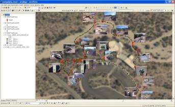
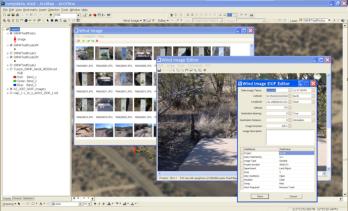
Flawless image integration for ArcGIS users. Imprint date time, GPS position
and attributes right onto your photos. Process photos into hyperlinked and
raster embedded datasets and process Ricoh track-logs. Wind image supports
all coordinate systems supported within ArcMap and all ESRI Geo-database
types (Personal,File and ArcSde). Other Features include: Native Support in
both ArcMap and ArcReader for viewing raster embedded datasets, photo
thumbnail viewer, a robust set of photo editing tools and integrated layout tools
for printing maps with your images. Fully support Esri ArcMap Version 9.2 to
10.1
Wind Image for ArcMap
Wind Image for ArcMap
Flawless image integration for ArcGIS users. Imprint date time, GPS position
and attributes right onto your photos. Process photos into hyperlinked and
raster embedded datasets and process Ricoh track-logs. Wind image supports
all coordinate systems supported within ArcMap and all ESRI Geo-database
types (Personal,File and ArcSde). Other Features include: Native Support in
both ArcMap and ArcReader for viewing raster embedded datasets, photo
thumbnail viewer, a robust set of photo editing tools and integrated layout tools
for printing maps with your images. Fully support Esri ArcMap Version 9.2 to
10.1
 Click here to download the Wind Image brochure
Click here to download the Wind Image Software comparison brochure
Click here to download a trial of Wind Image for Esri ArcMap
Click here to purchase a copy of Wind Image for Esri ArcMap online
Click here to watch Wind Image Training & Support videos online
Click here to download the Wind Image brochure
Click here to download the Wind Image Software comparison brochure
Click here to download a trial of Wind Image for Esri ArcMap
Click here to purchase a copy of Wind Image for Esri ArcMap online
Click here to watch Wind Image Training & Support videos online